Trip to the Big Island – Hawaii
I recently took a trip to the Big Island, Hawaii (Haah-VIE-ee) for sightseeing and to attend the Merrie Monarch Festival held in Hilo (HEE-low), the 2nd largest county seat and unincorporated city in the State of Hawaii.
We had an early morning flight on Hawaiian Airlines that required us to get up at 4:30AM. Our 47 minute flight left right on time about 6:30 AM.

The first thing one notice on stepping off the plane in Hilo, Hawaii is that it is cooler than Honolulu on the island of Oahu.
The second very noticeable thing is how much more space there is between buildings and there is no cramped downtown of high rise buildings and parking garages. Hilo is smaller, only about 49,000 residents, and much more rustic in appearance than Honolulu. Hilo is also the rainiest city in the United states – weather stations around the city report from 129 inches (3,200 mm) to over 200 inches (5,200 mm) a year of rain. The record rainfall in one day was just over 27 inches (691.9mm) set in the year 2000.
 |
| Hilo Bay looking from the waterfront park towards Mauna Kea Volcano |
The last noticeable thing about Hilo and the Big Island in general is that there is dark, black lava everywhere. Lava outcroppings are in people’s front yards, in the parks, and most retaining walls are built of lava. Where there is a break in the intense vegetation, you will see that it is growing on lava gravel or out of cracks in the lava.
 | |
| Lava outflow at the Waterfront Park in Hil |
We went for breakfast at a popular restaurant near the Hilo airport. Signs greeted the Merrie Monarch Festival visitors.
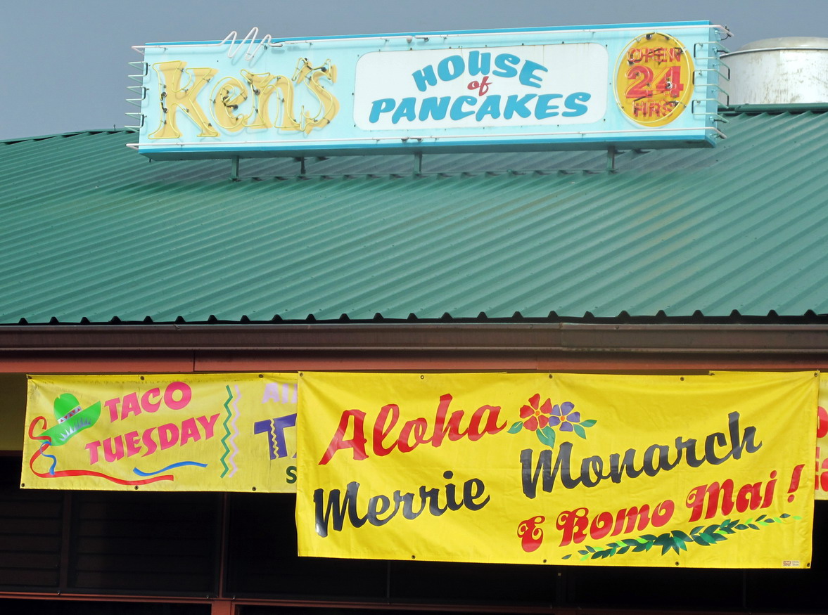 |
| Ken's House of Pancakes |
 |
| Part of the Breakfast Menu at Ken's - notice the emphasis on rice. |
My friends, Jan and Sherb wanted to pick up programs and the special T-shirts for the festival so we went to the community indoor gym and tennis facility where the festival was being held. We were much too early; the vendors had not yet set up their booths.
 | |
| Right the building for a Handicrafts Fair - rear the festival site | . |
We went to the waterfront park at the bay. The park is very beautiful and has been built on land that was once part of downtown Hilo. Now, it is now a memorial park dedicated to the victims of past devastating tsunamis flooding up the funnel shaped Hilo Bay into the city caused by earthquakes in the Aleutian Islands and Chile
 |
| Hilo - Waterfront Park |
 |
| A type of lily in the park |
 |
| Hilo - Waterfront Park |
We returned to the Festival grounds to buy our Merrie Monarch Festival shirts and then set off to Hawaii Volcanoes National Park which includes parts of the volcanoes Mauna Loa (Mannah LOW-ahh), Mauna Kea (Mannah KEY-ahh) and Kilauea (Kill-ahh-WAY-ahh). These 3 volcanoes form the southern portion of the island of Hawaii. There are two more in the Northern part of the island.
Click here for the Park Service's multi-media presentation
Click here for the Park Service's multi-media presentation
The island of Hawaii is the newest and largest of the Hawaiian Island group. There is a stable hotspot welling up from deep in the earth’s core that that has existed for tens of millions of years. The sea floor has been slowly moving to the Northwest over the hotspot, creating each of the islands over the eons as the hotspot causes repeated eruptions and lava flows. The hotspot is also creating a sea-mount about 30 miles south of the Big Island, which will become the island of Loihi (Low-EE-hee) in about 20,000 years - barring any major eruptions.
Kilauea has been in constant volcanic activity for the past 20 years or so. Kilauea’s recent lava flows have added almost 550 acres of new land on the South part of the Big Island as the lava pours into the sea.
Mauna Loa (Long Mountain) is one of several very tall mountains in the United States. The summit is at 13,677 feet (4,169 meters). Mauna Loa is the largest mountain in the United States by volume at 18,000 cubic miles of lava (79,000 cubic km) – it spreads all over and is very tall.
To look at the volcanoes from the Hilo area, you do not realize how big and high they are – you cannot get far enough away from them and the slopes of the volcanoes are rather shallow looking. Typically, when looking up towards their summits, you cannot see the tops due to the clouds that are forming as the wet air is being pushed up and over the high summits.
I was reminded of several large bed pillows thrown flat on a bed when I looked at Mauna Loa and Mauna Kea from Hilo during brief breaks in the cloud cover.
I was reminded of several large bed pillows thrown flat on a bed when I looked at Mauna Loa and Mauna Kea from Hilo during brief breaks in the cloud cover.
 |
| Map of the Big Island and the National Park |
We climbed out of Hilo entering tropical rain forests on state highway 11 to get to the Hawaii Volcanoes National Park. It was a cool, rainy day there on the Windward side of the island. I used my Lifetime Senior National Park Pass for a free entry to the park.
We stopped at the parks Visitor Center to learn about the volcanoes and of the hazards of being on or near a volcano. We learned that toxic fumes and sulfur dioxide gases were the main danger. Several roads and trails in the park were blocked off due to dangerous gases flowing from various fissures and vents.
We stopped at the parks Visitor Center to learn about the volcanoes and of the hazards of being on or near a volcano. We learned that toxic fumes and sulfur dioxide gases were the main danger. Several roads and trails in the park were blocked off due to dangerous gases flowing from various fissures and vents.
We also learned that the enormous weight of the volcanoes had caused the original seafloor under Hawaii to sink by about 6 km - about 3.5 to 4.5 miles
 |
| Jan & Sherb at the North Rim of Kilauea Caldera - steam in background |
 |
| North Rim of Kilauea Caldera - gas venting in background |
At the North rim of the Kilauea Caldera, the ground was warm under our feet. We stopped to see a field of steam vents there. The vents were adding warm mist to the cool drizzle of rain as we went to the edge of the caldera for a good look. The rainwater soaks into the fractured, permeable lava until it finds underlying layers of lava that are hot enough to boil off the water as steam.
After taking photos we proceeded on to the Jagger Museum and the Hawaii Volcano Observatory. The museum overlooks Kilauea crater named Halema’uma’u (HALL-ey-mah=oomah-oo) Crater.
 |
| View from the terrace at the Jagger Museum in the National Park |
Jan and I saw some quite rare Hawaiian Yellow Finches while at the museum. The birds are mostly seen farther north on the Western shore near the town of Kona. (Cone-ah)
 |
| Yellow Finch - usually found near Kona |
We drove along the Eastern Rim of Kilauea Caldera through the thick rainforest on both sides of the road intending to stop at the Thurston Lava Tube and to descend the Chain of Craters Road to the South Shore of the island where the lava flows have fallen into the sea.
 |
| Mossy plants in the rainforest |
 |
| A forest of large ferns on the windward side of Kilauea |
 |
| Kilauea Iki crater overlook |
 |
| The bottom of Kilauea Iki Crater |
We stopped at the rim of Kilauea Iki (EEK-ie) crater for some photos and then on to the parking area at the Thurston Lava Tube.
Lava tubes are formed when a stream of molten lava races downward. The top and side edges of the stream solidify as it cools down. The now solid lava insulates the hotter flow of liquid lava keeping it from cooling. The hot fluid lava continues flowing through the tube that is formed. If the eruption of lava subsides, the liquid hot lava drains out of the tube leaving a hollow tunnel through the lava flow area.
The Thruston Lava Tube is an example that you can walk through.
 | |
| Pathway down to the lava tube entry |
 |
| At the entry of the lava tube - condensation on the camera lens causing light diffusion |
 |
| Looking back up the path from the lava tube entry |
The tube was damp, very dark in places and the pathway is uneven. My friend Jan reports that when she was here 35 years ago, the Park Service had not installed minimum lighting, nor had they done anything to smooth the path.
 |
| Inside the Thurston Lava Tube |
 |
| "There is a light ahead!" - Exit ahead |
 |
| Jan and the outside view of tube exit point |
The National Park is situated on land that has religious significance to Native Hawaiians. Pelehonouamea (Pell-AY-hahn-O-oo-ahh-me-ahh) or Pele (Pell-AY) is the goddess of all things volcanic. The mana (Mahn-ahh) or spiritual energy of Pele is powerful and while on a volcano – is all around you.
It is best to be respectful of Pele - as countless thoughtless souvenir hunters will tell you. They have picked up bits of lava rock from the volcanoes and taken them home only to have bad luck and misfortune in their lives from then on. Every day the Hawaiian Volcanoes National Park service receives mailed packages with lava rocks in them with notes to explain that the sender is hoping that by returning the lava rocks to Pele, they will restore their good fortune.
There is a tree called the Ohia (oh– HE- ahh) that takes root on the lava soon after eruptions. It is part of the recovery process that the barren lava fields go through to regain plant and animal life.
Blossoms of Ohia in great abundance can be found on the mountain slopes of young volcanoes such as Kilauea, Mauna kea, and Mauna Loa. The crimson red Lehua (LAY-how) flower called the flowers of Pele bloom twice a year (beginning of spring and in early autumn). The flowers are stunningly beautiful.
Ancient Hawaiians were equally fascinated by the beauty of the Ohia Lehua.
 |
| Lehau blossoms of the Ohia Tree |
It is unclear how the legend of "tragic love" behind the meaning of this flower came to be. In fact, the flower and tree are known as sweethearts of the Goddess Pele: young and handsome, Ohia visits Kilauea and Pele falls in love with him at first sight. Ohia resists her advances and an angered Pele turns him into the tree known as Ohia.
According to the Hawaiian legend, it is said that you must not gather the Lehua flower because when the Lehua and Ohia separate, their sadness brings rain.
We continued to descent from the 4,000 foot high area around Kilauea Caldera down the Chain of Craters Road driving through lava flows from recent eruptions. The new, very tortured lava fields are barren until seeds are brought in by wind, animals and birds.
 | |||||||
| A recent lava flow |
 |
| Chain of Craters Road |
From several observation posts, you could see the coastline with the different tracks of lava flows over the years. The more recent eruptions leaving coal black areas and older flows starting to regain vegetation. The road was blocked to keep visitors away from the rift area where the most recent eruptions and lava flows are.
 |
| Various eruptions of lava descending to the sea. |
 | |
| From an obersvation post to the sea - the darkest lava flows are new |
We returned to Hilo after making a stop at Rainbow Falls Park near a friend’s home where we spent the 5 nights we were on the Big Island.
 |
| Rainbow Falls Park in the City of Hilo |
We stopped for a very late lunch or early dinner and then off to our beds early.
No comments:
Post a Comment
Your comments and criticism are appreciated. Thank you !